

Subtotal: 639.90$


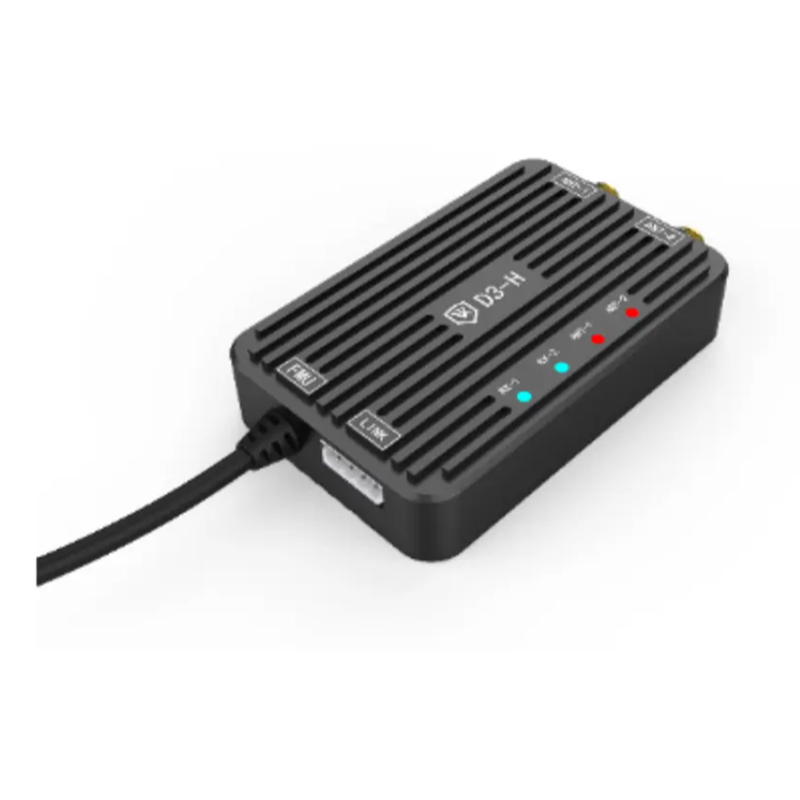
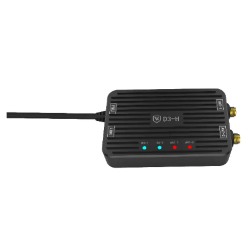
D3-H Dual Antenna RTK Heading Module | Centimeter GNSS Direction Finding Unit for Industrial UAV
D3-H industrial dual-antenna RTK positioning module with real-time heading measurement, multi-constellation GNSS, IP65 enclosure, compatible with V10-PRO flight controller. Ideal for survey, inspection, VTOL & agricultural drones, stable operation at 30–34℃ ambient temperature
Product Description
Product Overview – D3-H RTK Heading Positioning Module
The VK-FLY D3-H is a professional dual-antenna RTK heading positioning module independently developed by VK-FLY (Weike UAV Tech). It integrates multi-system GNSS receiver and real-time attitude heading calculation algorithm, designed to solve low-precision yaw and heading drift issues of single-antenna GNSS modules on industrial UAVs.
Fully plug-and-play compatible with VK-FLY V10-PRO industrial flight controller, D3-H outputs centimeter-level horizontal positioning data and accurate aircraft heading angle synchronously. It supports fixed base station RTK and mobile dynamic takeoff & landing modes, perfectly matching VTOL fixed-wing drones, heavy-lift multirotor, aerial survey UAVs and large agricultural plant protection drones.
The module adopts integrated heat dissipation shell with IP65 dustproof and splash-proof grade. It runs stably under ambient temperatures ranging from 30°C to 34°C, adapting to high-temperature farmland, open-air survey sites and outdoor inspection scenarios without positioning failure or data delay.
Core Competitive Advantages of D3-H RTK Module
- Dual-Antenna Real-Time Heading Measurement
Two-channel GNSS signal reception, calculate drone heading in real time, eliminate magnetic compass interference caused by large power batteries and metal frames, greatly improve low-altitude flight stability.
- Multi-Constellation Dual-Frequency RTK, Centimeter Accuracy
Supports BDS, GPS, GLONASS, Galileo multi-satellite systems; horizontal positioning accuracy ≤2cm, heading angle error less than 0.3°, fast cold start within 28 seconds.
- Wide Working Temperature Adaptability
Stable continuous operation under ambient temperature of 30–34°C, wide working temperature range -20℃ ~ +60℃, no performance attenuation in high-temperature outdoor environments.
- Industrial IP65 Dust & Splash Proof Enclosure
Integrated aluminum alloy heat dissipation shell, anti-pesticide splash, field dust and light rain, long service life for all-day outdoor UAV operations.
- Native Matching VK-FLY Flight Control Ecosystem
Direct serial communication with V10-PRO autopilot via CAN bus; positioning and heading data automatically synchronized to ground station, support automatic route planning, terrain follow and precise hovering.
- Dual Working Modes for Flexible Deployment
Support fixed RTK base station mode and mobile dynamic takeoff/landing mode, suitable for short-distance farm survey and long-distance cross-region mapping missions.
- Compact & Lightweight Structure
Miniature integrated design, small installation footprint, low load weight, no extra flight resistance for medium & large industrial UAV platforms.
H2 Complete Technical Specification Table
| Parameter | Specific Technical Data |
|---|---|
| Model | D3-H Dual-Antenna RTK Heading Module |
| Satellite Support | BDS B1I/B2a, GPS L1/L5, GLONASS L1, Galileo E1/E5a |
| Positioning Accuracy | RTK Horizontal: ≤2cm; Vertical: ≤3cm |
| Heading Accuracy | ≤0.3° (Baseline ≥30cm) |
| Cold Start Time | ≤28s |
| Protection Class | IP65 Dustproof & Splash-proof |
| Ambient Stable Operating Temp | 30°C ~ 34°C |
| Full Working Temperature Range | -20℃ ~ +60℃ |
| Communication Interface | CAN serial, compatible with VK V10-PRO flight controller |
| Working Modes | Fixed RTK base station mode / Mobile dynamic takeoff mode |
| Core Output Data | Centimeter positioning coordinates + real-time drone heading angle |
| Application Platform | VTOL UAV, heavy-lift multirotor, mapping drone, agricultural spraying drone |
Main Application Scenarios
-
Vertical Takeoff & Landing VTOL Inspection Drones
Accurate heading correction during transition flight between vertical and horizontal flight, avoid course drift during mountain power line patrol.
- Aerial Survey & Mapping UAVs
Centimeter-level ground coordinate collection, guarantee orthophoto and point cloud mapping precision for land survey projects.
- Large Agricultural Plant Protection Drones
Stable heading control under 6-level crosswind, realize uniform variable spraying in orchards and farmlands with ambient temperature 30–34℃.
- Heavy-Lift Cargo Delivery Multirotor UAVs
Precise heading lock during automatic takeoff and landing, improve safety of logistics drop missions.
- Emergency Rescue & Public Security Monitoring Drones
Reliable positioning and heading output under complex terrain and high-temperature open-air environments.
- Industrial UAV System Integrator Matching Solution
Standardized RTK heading sensor for customized medium-to-large industrial drone projects.
Matching Installation & Working Modes
-
Fixed Base Station RTK Mode
Match with VK-FLY D2B/D3B RTK base station, set fixed reference point on the ground; D3-H airborne module obtains centimeter positioning and heading data via differential signal, for long-time fixed-area mapping and inspection tasks.
-
Mobile Dynamic RTK Mode
No fixed ground base station required, support dynamic takeoff and landing; D3-H self-completes differential positioning calculation, ideal for handheld field boundary survey and mobile farm mapping work.
- Flight Control Docking Mode
Two dual-frequency GNSS antennas are installed symmetrically on both sides of the drone fuselage; connect D3-H module to V10-PRO flight controller via CAN port, heading and positioning data automatically participates in flight control algorithm to optimize hovering stability and route tracking effect.
FAQ Section
Q1: Which flight controllers are compatible with VK-FLY D3-H RTK heading module?
A: It achieves plug-and-play seamless connection with VK-FLY V10-PRO industrial flight controller; it also supports secondary development docking with all autopilots that comply with MAVLink protocol.
A: It achieves plug-and-play seamless connection with VK-FLY V10-PRO industrial flight controller; it also supports secondary development docking with all autopilots that comply with MAVLink protocol.
Q2: How accurate is the heading measurement of D3-H?
A: When the baseline distance of dual antennas reaches 30cm or above, the heading angle error is less than 0.3°, effectively solving magnetic compass interference problems of large industrial drones.
A: When the baseline distance of dual antennas reaches 30cm or above, the heading angle error is less than 0.3°, effectively solving magnetic compass interference problems of large industrial drones.
Q3: Can D3-H work stably under high temperature of 30–34 degrees Celsius?
A: Yes, the module is equipped with independent heat dissipation aluminum shell, designed for stable continuous operation at 30°C to 34°C ambient temperature, no positioning drift or signal loss in high-temperature farmland and open-air environments.
A: Yes, the module is equipped with independent heat dissipation aluminum shell, designed for stable continuous operation at 30°C to 34°C ambient temperature, no positioning drift or signal loss in high-temperature farmland and open-air environments.
Q4: What’s the difference between D3-H and ordinary single GNSS modules?
A: Single GNSS only outputs position data without heading angle; D3-H dual-antenna design synchronously provides high-precision position and real-time heading, which is essential for VTOL and large multi-rotor industrial drones.
A: Single GNSS only outputs position data without heading angle; D3-H dual-antenna design synchronously provides high-precision position and real-time heading, which is essential for VTOL and large multi-rotor industrial drones.
Q5: Does D3-H support mobile dynamic RTK without fixed base station?
A: D3-H has dual working modes, including mobile dynamic takeoff & landing mode, which can complete differential positioning without ground fixed RTK base station, more convenient for field mobile survey.
A: D3-H has dual working modes, including mobile dynamic takeoff & landing mode, which can complete differential positioning without ground fixed RTK base station, more convenient for field mobile survey.
Be the first to review “D3-H Dual Antenna RTK Heading Module | Centimeter GNSS Direction Finding Unit for Industrial UAV”
Related Products




Reviews
There are no reviews yet.